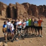
Yoram Rubin has been kind enough to share some of his day to day challenges and experiences with us as well as photos from his ride. Let him take you from packing, to breaking his personal cycling records, to Shabbat, and all the sights along the way.
Pre-Ride, November 8, 2011: Some Assembly Required
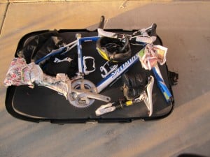
Finally, a 6 year dream come true and the date has arrived. After several months and miles of training, I am ready. The bike is disassembled and packed inside the hard case. Tomorrow, Miri and I will be on the way to Israel, arriving on Sunday afternoon. I will be in Jerusalem on Tuesday morning assembling the bike and test riding the bike with a final tune up. The ride will start on Wednesday morning with total of 79 bikers.
[line]
Day 0, November 8, 2011: Arrival in Jerusalem
 We arrived in Israel safely. The flight was uneventful which is a good thing.
Today, I arrived in Jerusalem for an over night stay. The ride will start tomorrow at 6:30AM. This afternoon I assembled my bike and took it for a short ride in Jerusalem to check the bike. Every things seemed to be in order. If you are interested in the route go to the following link: http://connect.garmin.
The weather is fantastic–about 72 degrees–with clear sky. It is anticipated that the rest of the week will be the same. Tomorrow the route is 65 miles long.
[line]
Day 1, November 9, 2011: Record Breaking Travel
 Today was a fantastic day. I broke my long distance record and level of difficulty. The ride started from Nave Shalom (Oasis of Peace) a community next to Jerusalem where Jews and Palestinians choose to live together and educate their kids in a dual curriculum, Hebrew and Arabic. The ride was great, the view was beautiful, and we stopped for lunch at Bell Caves (right). Bell Caves were created when people in the 4th century were digging for building material. They discovered that after digging for 6 feet in hard rock, there is very soft ground used for building material. When you look at picture you can see the white material which is soft and, at the top, a small hole which they created to get access to the soft material.
Statistics:
- Duration (from the time we took off to the time we arrived, including all the stops): 8:40 hours
- Distance: 67.51 miles (my previous record was 65 miles)
- Elevation Gain: 3,730 feet
- Link to today’s ride: http://connect.garmin.com/activity/127584383
[line]
Day 2, November 10, 2011: Nir Am and Gaza
- Nir Am Reservoir, a JNF agriculture reservoir with a view of the Gaza strip
- The Besor Wadi, the ancient southern boundary separating Israel from the Philistines
- End at Mashabei Sade, a kibbutz in the northern Negav.
Today the ride from Ashkelon to Mashabei Sade was very beautiful. The last segment was difficult even though today’s ride was somewhat easier than yesterday. I broke 2 records today. The first one is the longest distance 68.64 miles, breaking yesterday’s record. The second one is 2 consecutive days with a riding distance over 67.51 miles.
Today we stopped at Nir Am overlooking the Gaza strip which is less than a mile away. You may have heard about Nir Am in the news as one of the Kibbutez that was bombarded from Gaza. Lucky for us, there was no exchange of fire today.
There was an overview at Nir Am about the water sources in Israel. For many years after the establishment of Israel, water was a scare resource. Over the years, Israel has developed new technologies to resolve this issue. At present time, Israel is at turning point where it has all the water it consumed. In the near future it is anticipated that there will be a water reserve. The new technologies that Israel has developed are:
- Dripping system for agriculture irrigation,
- Desalination of salt water into fresh water,
- Recycling 85% of sewage and using it for agriculture, The highest percentage in the world.
Statistics:
- Duration (from the time we took off to the time we arrived including all the stops): 8:27:47 hours
- Distance: 68.64 miles (my previous record was 65 miles)
- Elevation Gain: 2,651 feet
- Calories: 2115
- Link to today’s ride: http://connect.garmin.com/activity/127723790
[line]
Day 3, November 11, 2011: Kibbutz Sde Boker
- Breakfast at Sde Boker, a desert kibbutz and site of Ben Gurion’s tomb (see view from his grave site).
- All riders will visit the grave site, with a view of the majestic Wadi Zin, a large canyon and seasonal stream.
- Take off-road bikes for 5 miles to Ein Akev, a desert spring in the wadi ( see picture).
- Lunch at Sde Boker. Avdat, a Nabatean mountaintop fortress, protecting the ancient spice trade caravan route.
- Arrive at Mitzpe Ramon, located atop Makhtesh Ramon, a giant erosion crater.
In 1955, Ben Gurion, Israel prime minister, drove from Eilat to Jerusalem. On the way he saw kibbutz Sde Boker and loved the place. He asked to join the kibbutz on the spot. The members told him they would let him know. The following day, they informed him that he was accepted as a member. As a result, he immediately resigned as prime minister and joined the kibbutz. He worked for 2 years in the kibbutz and then became prime minister again. He was always a member of the kibbutz where his house still is.
Statistics:
- Duration (from the time we took off to the time we arrived including all the stops): 9:22:54 hours
- Distance: 47.9 68.64 miles (my previews record was 65 miles)
- Total distance: 67.51+68.64+47.9 = 184.05 miles
- Elevation Gain: 3,760 feet
- Calories: 2,506
- Link to today’s ride: http://connect.garmin.com/activity/127951859
[line]
Saturday Rest, November 12, 2011: Mitzpe Ramon
and Makhtesh Ramon
It is a fanatic day at Mitzpe Ramon. Mitzpe mean vista point and Ramon means Roman; i.e. Roman vista point. Mitzpe Ramon is a small city in the Negev desert with many outdoor activities from hiking or biking in the Makhtesh, to horseback riding or watching the beautiful sun rise set.
There are 3 types of natural phenomena like this:
- Canyon where there is entrance and exit of water
- Crater from a meteor
- Makhtesh (right) where there is no entrance of water only an exit. Once there was an internal river inside the mountain which over the years caused the mountain to collapse. Even today during winter time you can find water running in the Makhtesh.
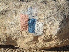
 I also attached a picture of the Israel Path sign. It goes from the north, Metula, all the way to the south, Eilat. There are three strips:
- White, representing the north month Hermon
- Blue, representing the Mediterranean sea
- Orange, representing south or the mountains color
As you can see, the stripes are not at the same height. The tallest bar represent the direction of north or south. In this picture, it is pointing to the south.
[line]
Day 4, November 13, 2011: Descent and Ascent
- Descent into Makhtesh Ramon, the largest erosion crater in Israel.
- Climb out of the Makhtesh.
- Lunch at Shittim , an old army base that has been turned into a desert ashram.
- Travel by kibbutz Ne’ot Smadar, the only fully organic kibbutz in Israel.
- Arrived at kibbutz Ketura, the home of the Arava Institute.
 Ne’ot Smadar visitor center: The strange looking vent is a cooling system with no electricity. It was designed for the outside wind to enter the vent and mix with droplets of water for cooling.
 Arava Institute solar energy research and validation: Researching new solar technologies for electricity and validating new designs for various companies.
 Bio Digester, low technology low cost system: converting animal manure and water to cooking gas and liquid fertilizer for communities without gas and electrical services in Jordan, West Bank, and Israel.
 A nice road sign not seen in the U.S.
Statistics:
- Duration (from the time we took off to the time we arrived including all the stops): 8:06:51 hours
- Distance: 63.13 miles.
- Total distance: 67.51+68.64+47.9+63.13 = 247.18 miles
- Elevation Gain: 2,726 feet
- Calories: 1,910
- Link to today’s ride: http://connect.garmin.com/activity/128430586
[line]
Day 5, November 14, 2011: The Big Finish
YES!!! I rode 293.92 miles in 5 daysI could on have done that without your emotional support with your positive feedback and emails to my daily updates and financial support.
On a personal note: The ride was very challenging for me, both the long distances and the ridding difficulties. On the third day, I felt a terrible pain in my legs after 10 miles. I shared my pain with an experienced rider he told me it is possible that my seat is too low. I raised it by 3/4″ and sure enough the pain was gone. In addition, I lost my voice on the last day and was getting sick. However, I rode today and came to the finish line. As the say goes: “mind over body.”
 Kibbutz Yotvata, home of a large dairy served by Arava communities.
- Tour of Timna and saw Solomon Pillars (see picture), home of the world’s oldest copper mines, ancient cultic temples, and geological formation.
- Arrived at the southern beaches of Eilat.
Finally I arrived at Eilat and jumped into the red sea. I took picture with my lovely wife at the end of the ride. I could not have done the ride without my wife, Miri, encouragement, support, help, assistance, and insisting on weekly training.
- Duration: 6:45:15 hours
- Distance: 46.74 miles
- Elevation Gain: 1,568 feet
- Calories: 1709
- Link to today’s ride: http://connect.garmin.com/activity/128739594
Total Distance: 293.92 miles
[line]
- Learn more about the Israel Ride
- Support a rider
- Like the Israel Ride on Facebook
- Follow the Israel Ride on Twitter


Fantastic blog Yoram! I made the journey last year and I feel connected again. Mazel Tov to you and all your co-riders. I’ll be back next year.
I miss it so. But am very proud of you, me and the other 79 riders. We kicked ass! Stay in touch.
Yoram, nice record of the highlights of each day, thank you for recording this for the rest of us. Good Shabbes, seems like yesterday you were wearing your swim trunks at Mitzpe Ramon and getting chided by Miri!
Great! Thanks for doing this Yoram. It’s wonderful having the gamin information. Now I know why the first day was so hard. Five miles of almost nonstop uphill! Take care.