The Hazon Ride was a profoundly moving experience for me. Riding over one hundred miles that weekend is one of my greatest accomplishments. At the end of my ride I broke out in spontaneous and unexpected tears.
Our routes for Friday and Sunday utilize back roads and bike routes in Sonoma and Marin Counties. Our Friday route consists of a loop leaving from Walker Creek Ranch, with three route options of 41, 61, or 81 miles. On Sunday we have 32 and 48 mile route options that end in San Francisco. The 32-mile option will involve taking a shuttle bus to the starting point.
All routes are fully supported, including detailed turn sheets and marked roads along the route. We provide rest stops every 15-20 miles with bathrooms, shade, water, and plenty of food and energy drinks. There are mechanics and medics on the route, as well as other crew to provide SAG (support and gear) assistance as needed.
Route Details
Day One (Friday): Loop Ride in Sonoma County
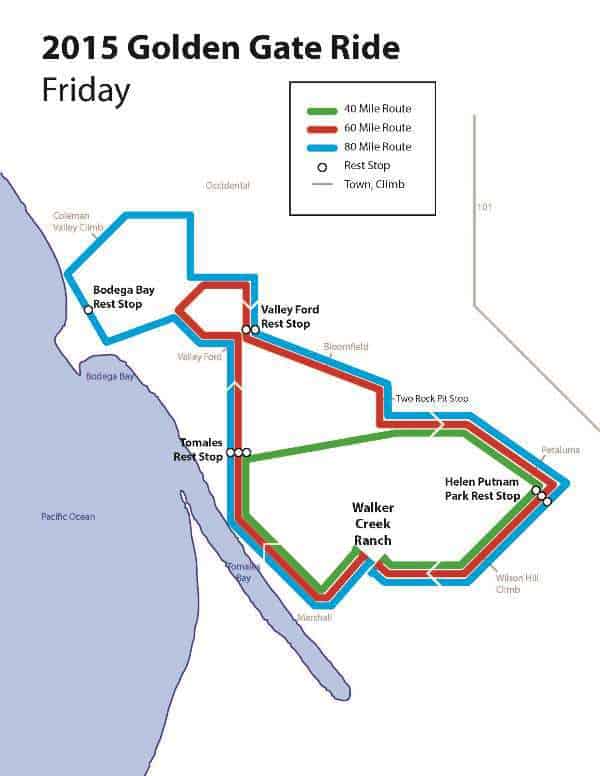 All routes begin heading west toward the ocean. We all climb our first hill coming out of Walker Creek Ranch, ascending 500 feet and then descending 700 feet to Marshall, California—an old dairying community now home to the fabled Straus Family Creamery. From there, we enjoy a relatively flat ride with views of Tomales Bay, cruising along the stream that becomes Walker Creek. At mile 14, we reach the town of Tomales and rest together at Tomales Community Park.
This is the first point of divergence.
40-mile Riders head east toward Petaluma, diverging from the other routes on a 5-mile stretch with limited climbing. They rejoin the shared route outside of Petaluma, but get first dibs on the sights, since longer riders won’t reach it until much later in the day. Fuel and psych yourself up at our Helen Putnam Park rest stop before your final climb up Wilson Hill, another 500-foot ascent. Take your time coming down and then coast your way along back to Walker Creek Ranch.
From Tomales Community Park, the 60- and 80-milers head north and west to explore additional small Sonoma county towns. 60-milers will do a short loop north of Valley Ford, before returning to Valley Ford for their second rest stop. From there, they head south east, eventually rejoining the 40-mile route outside of Petaluma, for the final rest stop and climb of the day.
Meanwhile, the 80-milers are still out on the road. They head further west towards the coast and a rest stop in Bodega Bay. They then have a tough climb before returning the Valley Ford rest stop. They rejoin both the 60- and 40-mile routes for the final rest stop at Helen Putnam Park and the final climb up Wilson Hill.
View Larger Map, where you can click to view individual route options
Day Two (Sunday): Marin to San Francisco

On Sunday, we offer two route options. Our 31-mile riders will start the day with a shuttle, and start riding at the first rest stop. The 48-mile riders will start by cycling through the countryside in northern Marin county. This bit is mostly uphill at the start, but you are rewarded with a great downhill towards the Nicasio reservoir.
After the first rest stop we have a few more climbs and a great descent into Ross Valley. We ride through various small towns in southern Marin County, using a combination of back roads, signed bike routes, and some bike trails. After winding through Sausalito we climb up to the Golden Gate Bridge and enjoy the long ride across. We end the day riding through the Presidio and a few miles on city streets before we reach our closing location at the Jewish Community High School of the Bay.
View Larger Map, where you can click to view individual route options
Elevation Charts
Please note that the scale of each map is slightly different. You can get a full map for each route by clicking on the RideWithGPS link.
Click each image for a larger version.
Day 1: 41 mile option | RideWithGPS
Day 1: 61 mile option | RideWithGPS
Day 1: 81 mile option | RideWithGPS
Day 2: 31 and 48 miles | RideWithGPS
The 31 mile route will have a shuttle to the point marked with the red line. The gap at the end is the Golden Gate Bridge.


